-
En live
1 - ski nordiqueMise à jour : 25 février 2025 - 12:54
- Col de Marcieu
- Col de Porte
- Le Désert d'Entremont
- Le Granier
- Le Sappey en Chartreuse
- St Hilaire du Touvet
- St Hugues / Les Egaux
- Le Planolet
WeatherTotal snow depthSki lifts0/4Mise à jour : 14 avril 2025 - 14:09 -
Book
online -
Shop
online


Itinéraire raquettes - L'Ecoutoux
Sport, Winter sports, Snowshoe itinerary
in Le Sappey-en-Chartreuse
3.3
km
3h 30min
Hard
-
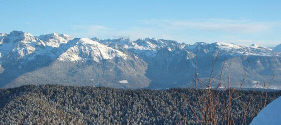
Round trip for good walkers, in the forest with some steep slopes but the game is worth the candle: at the top, the panorama is breathtaking.
-
An out-and-back route for good walkers, in woodland with a few steep inclines, but well worth the effort: at the top, the panorama is breathtaking.
Distance: 9.0 km round trip
Duration: 3h 30min
Difficult
- Departure
- Le Sappey-en-Chartreuse
-
-
Difference in height
- 360 m
-
-
-
Plain text period
-
From 01/12 to 31/03.
Subject to favorable weather.
-
-
-
Environment
-
-
-
Spoken languages
-
-
-
-
-
Documentation
- GPX / KML files allow you to export the trail of your hike to your GPS (or other navigation tool)
-
- See all reviews
- 360 meters of difference in height
-
- Maximum altitude : 1386 m
- Minimum altitude : 991 m
- Total positive elevation : 360 m
- Total negative elevation : -15 m
- Max positive elevation : 360 m
- Min positive elevation : -13 m
Services
-
-
Services
-
